Map of Cyprus: Districts, Towns, Villages and the Green Line
The six districts of Cyprus and their main towns in English and Greek, the UN buffer zone, the British bases and where to find an official map with villages.
Checked: 25 October 2026.
Map of Cyprus: a brief overview
Cyprus is the third-largest island in the Mediterranean: according to the Deputy Ministry of Tourism, it covers an area of 9,251 km². The island is divided into six administrative districts — Nicosia, Limassol, Larnaca, Paphos, Famagusta and Kyrenia — and a UN buffer zone approximately 180 km long runs across it from west to east.
On any map of Cyprus, it helps to tell apart three layers: the districts with their towns and villages, the dividing line with the buffer zone, and the two British sovereign bases in the south. According to the Cyprus Ministry of Foreign Affairs, following the Turkish invasion of 1974, more than 36 per cent of the territory of the Republic of Cyprus remains under occupation by the Turkish army, and the government does not exercise effective control over that area.
This article describes the island from the inside: what lies where, what the towns are called in English and Greek, and where to find an official map with villages. Where Cyprus lies in the world and how far it is from neighbouring countries is covered in a separate article, ‘Where is Cyprus? Map and island location’.
The six districts and their main towns
The districts (επαρχίες, eparchies, in Greek) are named after their main towns. Nicosia (Lefkosia, Λευκωσία) is the capital in the centre of the island. Limassol (Lemesos, Λεμεσός) lies on the south coast, Larnaca (Λάρνακα) in the south-east and Paphos (Pafos, Πάφος) in the west.
Famagusta (Ammochostos, Αμμόχωστος) is on the east coast and Kyrenia (Keryneia, Κερύνεια) on the north coast. The entire Kyrenia district and most of the Famagusta district lie beyond the line of demarcation. Paralimni, Ayia Napa and Protaras are situated in the government-controlled part of the Famagusta district.
Nicosia is a divided capital: its northern part also lies beyond the line. According to the United Nations Peacekeeping Force in Cyprus (UNFICYP), in the Old Town the buffer zone is in places only a few metres wide, so on a detailed map of the centre you can see streets running straight into barriers.
Municipalities and villages following the 2024 reform
A new system of local government has been in force in government-controlled territory since 1 July 2024. As reported in the press when the reform came into force, 30 former municipalities and 50 communities have been merged into 20 new municipalities, villages have been grouped into 30 community service complexes, and district self-government organisations have been set up.
A further nine municipalities — Akanthou, Famagusta, Karavas, Kyrenia, Kythrea, Lapithos, Lefkoniko, Lysi and Morphou — are located in the occupied part. According to the Union of Cyprus Municipalities, they retain their legal status, and their mayors and councils are temporarily operating in the south; there are 29 municipalities in Cyprus in total.
Consequently, on both old and new maps and in documents, the same village may be listed in different ways: as an independent community or as part of a merged municipality. It is advisable to check the current administrative division against official sources rather than tourist maps from previous years.
The dividing line and the UN buffer zone
The buffer zone, also known as the Green Line, follows the lines where troops came to a halt following the ceasefire on 16 August 1974. According to UNFICYP, it stretches for approximately 180 km: in Old Nicosia it is several metres wide, whilst in other places it is several kilometres wide.
This is not an uninhabited strip. According to UNFICYP, more than 10,000 people live or work in the villages and civil use areas inside it, and Pyla is the only village where Greek Cypriots and Turkish Cypriots live side by side. Outside the civil use areas, civilians need authorisation from UNFICYP.
The line may only be crossed via official crossing points. The Customs Department of the Republic of Cyprus, in a list updated on 25 November 2021, names Ledra Palace and Ledra Street in Nicosia (pedestrians only), Agios Dometios, Astromeritis–Zodhia, Kato Pyrgos–Karavostasi, Lefka–Apliki and Deryneia, as well as Pergamos and Strovilia in the British Dhekelia base.
The British bases of Akrotiri and Dhekelia
The two UK Sovereign Base Areas remained under British jurisdiction under the 1960 Treaty of Establishment of the Republic of Cyprus. According to the bases’ administration, they cover 3 per cent of the island’s territory, totalling 98 square miles: the Akrotiri base near Limassol covers 47.5 square miles, and the Dhekelia base near Larnaca covers 50.5 square miles.
Most of the land on the bases belongs to private owners, not to the British Government. According to the administration, around 10,000 Cypriots live on the bases, and within the Dhekelia base there are three enclaves of the Republic: Ormidhia, Xylotymbou and the Dhekelia power station.
Maps usually show the bases with their own boundary. This is important for travellers: the rules set by the base administration apply within the base, including on the beaches and near military installations, and the Pergamos and Strovilia crossing points lie inside the Dhekelia base.
Mountains, plains and the coast
The terrain divides the island into several regions. In the centre and to the south-west rise the Troodos Mountains; along the northern coast stretches the Pentadaktylos Range, or the Kyrenia Range; and between them lies the Mesaoria Plain, where Nicosia is situated. Along the edges of the island are coastal plains and river valleys.
The highest point in Cyprus is Mount Olympus, or Chionistra, in the Troodos Mountains: according to the Department of Forests, it stands at 1,952 metres. The Troodos map is dotted with mountain villages, monasteries and walking trails, whilst the main towns, apart from Nicosia, are situated on the coast.
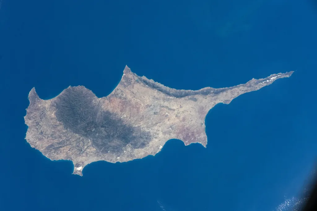
The shape of the island is easy to see on a map: to the east it extends into the long, narrow Karpasia Peninsula, while to the west it ends with the Akamas Peninsula; these promontories are also visible in satellite images.
Where to find an official map with villages
Official maps of Cyprus are produced by the Department of Lands and Surveys of the Ministry of Interior. Its portal has an Interactive Maps section and the INSPIRE Geoportal; the default language is Greek, and an English version is available.
Paper tourist maps of the island and its towns are usually available from the Deputy Ministry of Tourism’s information offices, and visitcyprus.com publishes material for travellers. Place names are written in both Greek and the Latin alphabet on road signs, so it is useful to know both versions of a place’s name.
Before travelling north, check the current list of crossing points on the Customs website and the rules for crossing. A map shows roads across the dividing line, but it may be crossed only at official crossing points, and outside the civil use areas you must not enter the buffer zone without authorisation from UNFICYP.
Continue planning
- Where is Cyprus? Map and island location
- Northern Cyprus: Status, Crossing the Line and What to Check
- Cyprus Green Line: crossings and travel to the north
Official sources
- Deputy Ministry of Tourism: about Cyprus
- Cyprus Ministry of Foreign Affairs: important information on travel to the Turkish-occupied area of Cyprus
- UN Peacekeeping Force in Cyprus (UNFICYP): about the buffer zone
- Customs Department of the Republic of Cyprus: crossing points
- Union of Cyprus Municipalities: occupied municipalities
- Sovereign Base Areas Administration: background
- Department of Forests: Troodos National Forest Park (leaflet)
- Department of Lands and Surveys: maps and cadastral portal
Cyprus from the International Space Station, September 2024 · Photo: NASA Johnson Space Center · Public domain · converted to WebP and resized.
