Mount Olympus, Cyprus (Chionistra): the island’s highest peak
About the place
Checked: 25 October 2026.
Mount Olympus (Chionistra): what it is and where
Olympus, or Chionistra (Όλυμπος, Olympos; Χιονίστρα, Chionistra), is the highest peak in Cyprus, in the Troodos mountains. According to the Department of Forests, it is 1,952 metres high. The peak is in the Limassol district, within the Troodos National Forest Park, which is managed by the Department of Forests of the Ministry of Agriculture.
The Cypriot Olympus should not be confused with the mountain of the same name in Greece. The name Chionistra is linked to the Greek word for ‘snow’, and in tourist material the peak is usually called Mount Olympos or Mount Olympus. Some official documents also give a height of 1,951 metres, but the Department of Forests gives 1,952 metres.
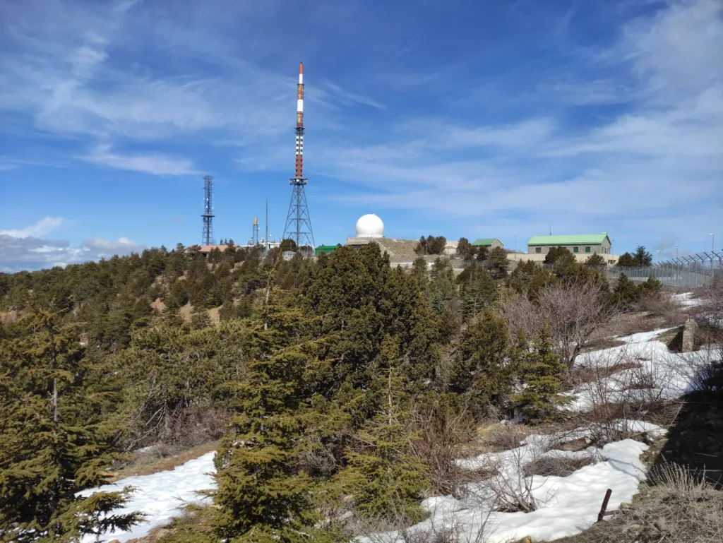
The summit itself is taken up by fenced military and technical installations, so you cannot reach the highest point. People come for the views, the old pine forest, the nature trails around the summit and the winter snow. Our separate articles cover the ski runs on the slopes of Olympus and the villages of Troodos.
Nature and geology of the summit
The Troodos mountains are part of an ophiolite complex that the Department of Forests considers one of the best developed in the world, and scientists from many countries have long studied it. According to the Department of Forests, the ancient ocean crust these mountains are made of formed about 90 million years ago. It began to rise about 70 million years ago, and the first land appeared only about 15 million years ago.
Around the summit grows a forest of black pine, which dominates from 1,200–1,500 metres right up to Chionistra. Alongside it grow foetid juniper, wild service tree and cotoneaster. Many of the black pines and junipers at these altitudes are more than 500 years old, and a few trees up to 1,000 years, which is why they are strictly protected.
About 750 plant species have been recorded in the Troodos National Forest Park. Of these, 72 are endemic to Cyprus, and 12 grow only in this park and nowhere else in the world. Some plants are named after the area, such as the rose Rosa chionistrae, and typical birds of the park include the crossbill and the Cyprus wheatear.
Trails around Mount Olympus: Artemis and Atalanti
The best-known trail near the summit is the circular Artemis trail. According to Visit Cyprus, it is 7 km long and takes about 2.5–3 hours. The trail circles the summit at about 1,850 metres, with views in all directions. It starts about 300 metres from the junction where the Chionistra road leaves the Troodos–Prodromos road.
Along the way are the ruins of temporary fortifications that, according to Visit Cyprus, the Venetians built in the last years of their rule in Cyprus, before the Ottomans arrived in 1571. Two black pines estimated to be about 500 years old also grow here. The trail runs through black pine forest, past rock outcrops and spots with rare plants.
The Atalanti trail is longer: a 14 km circular route that starts and ends at Troodos Square. The park has 13 trails in all, about 65 km in total, and all of them are signposted. According to the Department of Forests, the best season for walking usually runs from April to November; our separate overview covers the island’s other trails.
Getting there and where to start
The starting point for a visit is Troodos Square, reached by mountain roads from Limassol and Nicosia. According to the Department of Forests, the Troodos forest lies about 40 km north of Limassol and 60 km west of Nicosia. Public transport into the mountains is limited, so it is easier to go by car or on an organised tour.
From Troodos Square the road leads to the Chionistra turn-off on the Troodos–Prodromos road, from where you can drive up to the summit and to the start of the Artemis trail. The mountain roads here are narrow and winding, so allow more time for the drive than the sat-nav suggests, and do not stop on bends.
About 200 metres west of Troodos Square is the national forest park’s visitor centre, reached by a paved path. There you can learn about the park’s nature, the state of the trails and the rules for behaving in the forest, and next to it is a short educational trail with geological and botanical exhibits.
Safety: weather, snow, fire and the military zone
The summit is noticeably colder than the coast, and fog, wind and rain can come in quickly. According to the Department of Forests, snow usually lies in January and February, and less often from December to March. In winter, roads and trails can be icy, so you need warm clothes and shoes with a good tread, and you should drive with care.
Forest fire is the main threat to the park, and according to the Department of Forests, destructive fires in Cyprus are caused only by people. Lighting a fire in or near the forest is against the law, even by the road; barbecues are allowed only in designated places at picnic sites. Do not throw away cigarette ends or matches; some unpaved forest roads may also be closed to protect against fire.
The summit has fenced military and technical installations, including radar facilities. Keep to the fences and prohibition signs and do not photograph military installations. In the warmer months, the blunt-nosed viper, also called the Levantine viper, can be found on the trails; it is dangerous if stepped on, so watch where you put your feet.
What is nearby
The villages, monasteries and waterfalls of the mountain area are described in our Troodos guide, so we do not repeat them here. Olympus combines easily with one of the villages on the slopes, such as Platres or Prodromos.
In winter, ski runs operate on the slopes of Olympus. Our separate article on skiing in Cyprus covers the season, the lifts and equipment hire.
If you want to walk other routes in the park, such as the trail to the Caledonia waterfall, see our overview of hiking routes and nature trails in Cyprus. It brings together trails of different lengths and difficulty.
What to check before you go
Before you go, check the Troodos forecast from the Cyprus Department of Meteorology, especially in winter and in the shoulder seasons. The Cyprus Police announce roads closed by snow and ice, and these announcements are worth checking on the day of your trip.
In summer, find out whether a high fire risk has been declared and whether any forest roads and trails are closed; the Department of Forests publishes this information. The state of the trails, any closures and the visiting rules can be checked at the park’s visitor centre.
If you are going for the snow or for skiing, ask the ski club about snow cover and whether the runs are open, because the season is different every year. Take water, a warm layer and a fully charged phone, and tell family or friends your route.
Continue planning
- Troodos: villages, trails and routes through the mountains of Cyprus
- Hiking routes and nature trails in Cyprus
- Skiing holidays in Troodos: the season and checking the conditions
Official sources
- Cyprus Department of Forests: Troodos National Forest Park leaflet
- Visit Cyprus: Artemis circular nature trail around Chionistra
- Visit Cyprus: Atalanti circular nature trail
The summit of Mount Olympus (Chionistra) with its radar dome · Photo: Fry72, Karel Frydrýšek · CC BY-SA 4.0 · converted to WebP and resized.
