The Venetian Bridges of Cyprus: access and walking route
About the place
Checked: 2 October 2026.
Three bridges and various routes
The term ‘Venetian bridges’ is often used to refer collectively to the stone bridges of Elia, Tzelefos and Roudias in the forested area of Paphos. These are three separate structures, not a single site comprising neighbouring arches. To plan your trip, first choose a specific bridge and how to get there, then decide whether you need to make any additional stops.
Names appear in various transliterations: Elias or Elia, Tzielefos or Tzelefos, Roudias or Roudhias. When searching on a map, check not only the name but also the location of the point you have selected. A mistake between the bridge, the start of the trail and the nearest village can significantly alter the final section of the route.
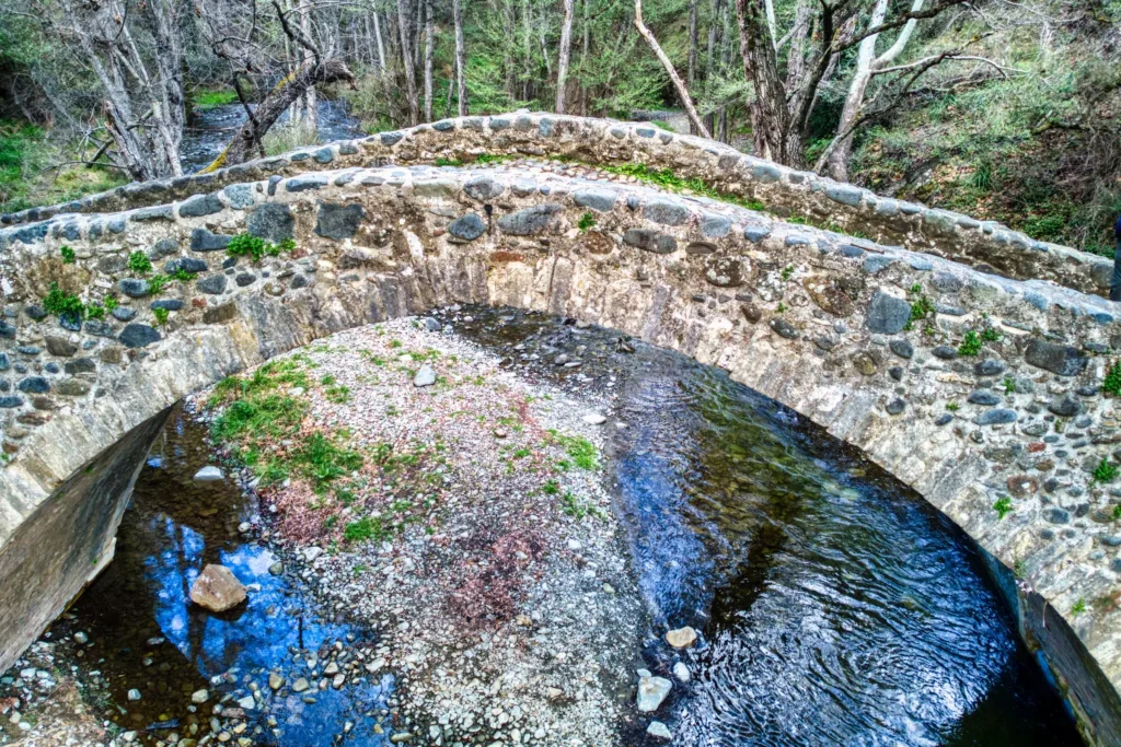
The photograph of the arch over the water does not show how challenging the approach and the entire walking route are. A visit can be either a brief stop at a single monument or a full-scale hike. Do not confuse these two types of visit when planning: they require different amounts of time, transport and preparation.
What is known about the history
The Department of Forests suggests that the bridges date from the 16th or 17th century and explicitly states that their exact age is unknown. Therefore, the common name ‘Venetian’ should not be taken as proof of a single date of construction. It is more appropriate to retain the name whilst separately explaining the limited information available regarding their age.
The bridges are associated with the historic caravan route along which raw materials, minerals and timber were transported from inland areas to the ports. This context explains the need for crossings over river valleys. However, it does not allow us to automatically identify a specific cargo or event for each surviving stone.
These sites are protected under heritage legislation. This means that any inspection must preserve the masonry and the surrounding historic environment. Do not move the stones, do not leave any inscriptions and do not use the arch for climbing: the small scale of the monument does not make it an ordinary, unprotected roadside structure.
Tzelefos: a visit to one bridge
Tzelefos is often chosen for a first visit to the area because of its distinctive stone arch and woodland setting. Plan your visit specifically to this bridge, checking the final turns and where to park your car. The fact that a location is marked on your sat-nav does not guarantee the condition of the road surface or that it will be accessible on the day of your trip.
Once you’re there, first assess the safe route to the bridge and the riverbank. Stay on a safe, authorised route; do not venture near the water just to replicate someone else’s shot. River levels and surface conditions vary; a calm stream in a summer photograph does not reflect the conditions after rain.
For a short visit, it is worth setting aside time not only to take a photograph, but also to read the information provided and observe the structure of the arch. If there are a lot of visitors, please do not block the passageway. If circumstances prevent you from getting close, a general view from a suitable vantage point remains a sensible option.
Elia and Roudias: planning separate visits
Elia is part of the official bridge route, but just because you’re visiting Tzelefos doesn’t mean it’s automatically easy to get there using the same route. Check the specific approach route and the walking section separately. Don’t add a waypoint just because the distance between the markers on the map seems short.
Roudias is situated on a different section of the forest trail. On the official map, it is linked to the route continuing towards Vretsia. If you are travelling by car, it is particularly important to check the condition of the forest roads: the fact that a walking route is shown on the map does not guarantee that the route is suitable for your vehicle.
If you want to see all three bridges, plan your route taking into account the return journey and daylight hours. A single long drive through the countryside requires more preparation than a few stops in town. If you don’t have reliable information about the route, it’s best to choose one accessible destination and save the others for another trip.
The walking trail and the return journey
The official guidebook describes a linear trail from the Kaminaria area to Vretsia, with a total length of around 17 km and an estimated walking time of 6–8 hours. This description applies to the full route, not just a walk to a single bridge. The booklet does not confirm that all sections are currently passable: you should check the conditions before setting off.
A linear route requires you to sort out your return transport in advance. If you walk back the same way, the distance roughly doubles to 34 km. Do not treat the entire route as an easy walk without any preparation, simply because the route’s name mentions three familiar bridges.
You can select individual sections provided you know their start and end points, their condition and how to return. Check the map against current signposts and information from the Forestry Department. The old official booklet is useful for planning your route, but it does not provide up-to-date information on which roads and paths are open.
Access, weather and forest protection
Use ordinary roads for the main part of the journey and check the conditions of the final forest section in advance. Do not automatically follow your sat-nav’s suggestion to take a short dirt track. Take into account your vehicle’s capabilities, the terms of your hire agreement and the weather; the absence of a warning on the screen does not mean the road is suitable.
For the walking section, take water, suitable footwear, an offline map and allow plenty of time before dark. After heavy rain or if the forecast is unfavourable, reassess the trip. You should not set off on the forest route based on an old description of conditions if the current situation is unknown.
Please observe the current forest regulations; do not light fires or leave litter behind. Do not damage vegetation or disturb wildlife. The bridges are particularly interesting because of the surrounding landscape, so preserving the woodland is just as much a part of visiting respectfully as preserving the stonework.
How to choose the right format
For your first trip, it is advisable to choose a single bridge with a confirmed access route and allow extra time for the journey. For a hike, you will need to check the trail separately and organise your return journey. These options are equally worthwhile, provided they are suited to the group’s level of preparation and the actual conditions.
If you are visiting with children or visitors with reduced mobility, please check the surface conditions, the distance from the car park and whether it is possible to view the monument safely. A lovely general photo does not confirm that the site is accessible. Do not promise that every participant will be able to cross the bridge without first checking the actual route and any on-site restrictions.
Before setting off, check the latest information from the forestry service and consult an official map. There is no guarantee that roads will always be open, that journey times will be accurate, or that all bridges will have been built on the same date. A good trip combines a specific destination, a tried-and-tested route and a respectful attitude towards heritage, whilst taking historical caveats into account.
Continue planning
- Troodos: villages, trails and routes through the mountains of Cyprus
- St Neophytos Monastery: frescoes and a visit
- The Sanctuary of Apollo Hylates: archaeology and visiting the site
Official sources
Photo: Hagai Agmon-Snir · CC BY-SA 4.0 · converted to WebP and resized.
