Cape Greco: how to plan your walks, views and the sea
A practical guide to Cape Greco between Ayia Napa and Protaras: entry points, trails, transport, heat, cliffs and a safe plan for the day.
Checked: 13 September 2026.
Where is Cape Greco and what to choose
Cape Greco is situated in south-eastern Cyprus between Ayia Napa and Protaras. The National Forest Park covers around 385 hectares and is part of the Natura 2000 network. However, for visitors, it is not a single site: trails, viewing points, coastal spots and access points are scattered throughout the area. First, choose your destination, then your starting point.
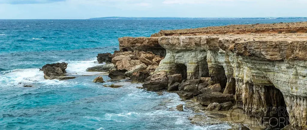
A practical visit could be a short walk to see a few sights, a full-length official trail, or a boat trip if the weather permits. These options cannot be safely combined without taking time and the heat into account. Photographs of sea caves, arches and chapels often depict different locations; there is a road between them.
A separate article on the national forest park maintains its conservation and reference focus. This page answers a different question: how a visitor can plan a specific day, get there, follow the route and return. This distinction prevents duplication and helps ensure that the entire park is not perceived as a single photo spot.
How to get there and choose a starting point
From Ayia Napa and Protaras, you can travel by car, taxi, seasonal public transport or bicycle, but not every option takes you right to the start of your chosen trail. Check the official description against the map and save the entrance coordinates. The name ‘Cape Greco’ at a bus stop or in an app does not guarantee proximity to your destination.
If travelling by car, only park where permitted. Do not drive off-road to cut corners, and do not block the barrier or emergency access. Cyclists should factor in the return climb, the heat and road traffic. The walk from the bus stop is included in the total route length and is not considered a free extra.
Before setting off, identify a turning point and a short alternative route. If public transport is infrequent, book your return journey first. A taxi at a remote location may not always arrive immediately, so arranging a pick-up in advance is more reliable than relying on an app. The group should have a shared plan for meeting up in case communication is lost.
Official trails and navigation
Choose a trail based on its official name, length, duration and difficulty. A circular route does not necessarily make the walk easier, and a short distance may involve walking over rocky terrain in direct sunlight. Download the route description before you set off and follow the signposts. A random, clearly visible path may lead to a cliff edge, private property or a difficult descent.
Take closed-toe shoes, water, a hat and sun protection. Ensure your mobile phone is fully charged and that you have an offline map. Do not set off on a long route at midday in summer. If you experience dizziness, weakness or nausea, stop in the shade, cool down and turn back; reaching your destination is not more important than your well-being.
Do not stray from the marked path just to take a photo, and do not cut corners through fragile vegetation. The National Forest Park requires you to behave responsibly: take your rubbish away, do not pick plants, and do not light fires. If there are fire restrictions or the route is closed, do not attempt to find an unofficial detour.
Cliffs, caves and coastal hazards
The coastal cliffs may look stable, but the edges may be eroded and crumble. Hold on to the railing and do not turn your back to the cliff edge just to get a photo. Strong gusts of wind are dangerous even when the sky is clear. Jumping from a height can result in hitting the rocks, injury upon entry, or being unable to get out of the water.
Assess sea caves based on current wave conditions and official access points. Do not enter them from land or water simply because you can see other people inside. The surf can block the exit, and wet rock is slippery. Swimming outside designated beaches does not provide lifeguards or safe water depths.
Boat trips are subject to wind, sea conditions and the captain’s decision. Check the route, safety equipment and cancellation terms before paying. Do not insist on visiting caves if the waves are unsafe. If the programme includes swimming, assess your own abilities, follow the crew’s instructions and do not stray from the group.
Itineraries lasting a few hours or a full day
For a short visit, choose one official walking tour and one accessible viewpoint. Start in the morning, allow time for the return journey, and do not include a beach at the other end of the area. This format is suitable for families and those exploring the local terrain for the first time. In hot weather, the route can be shortened without losing sight of the main objective.
A full day should be structured around a single long trail or a combination of a short trail with a break at a well-equipped beach away from dangerous cliffs. Lunch, water and transport should be planned in advance. A boat trip is best treated as a separate activity: its duration and dependence on the weather do not sit well with a strict walking schedule.
The sunset is beautiful, but it carries the risk of having to walk back in the dark. Only use a well-known, short route with authorised vehicle access, a torch and plenty of time to spare. Do not linger at the edge once it has got dark. If your return depends on a bus, the sunset must not cause you to miss the last service.
Seasonality and accessibility
In spring, the park is particularly interesting for its vegetation, but rain makes the rocks slippery. In summer, the main risks are the heat and the lack of shade. In autumn, the sea may remain warm, but the wind can change conditions quickly. In winter, a walk is possible in suitable weather, but the short days and reduced transport services mean you’ll need to set off early.
The nature trail is not barrier-free simply because there is a car park nearby. The surface, gradient and kerbs should be checked for the specific section. People with reduced mobility are advised to choose a confirmed viewing point and check in advance for accessible toilets. Being accompanied does not eliminate the risk at the cliff edge.
Following a storm, fire or maintenance work, access conditions may differ from those shown on the map. Follow the latest notices and pay attention to physical barriers on site. Do not apply information from an old blog to your current trip without checking it first. The official source sets out the route, but your own assessment of the weather and your fitness remains essential.
Pre-trip checklist
Check the wind and heat forecast, the trail’s condition, transport links and sunset time. Tell a friend your route, save the starting point’s coordinates and the emergency number 112. Take water, closed-toe footwear, sun protection, a small supply of food and a torch. For children, shorten the route to suit their abilities, not the pace of adults.
Once there, read the information board and make sure you are on the correct trail. Do not go past a ‘closed’ sign, a barrier or barrier tape. In the event of smoke, strong winds, feeling unwell or losing sight of the signposts, return via a safe, familiar route. When contacting the emergency services, give the official name of the trail and the geocode.
After the hike, check on the group and ensure there is enough water for the next activity. Do not drive whilst extremely tired. This guide helps you decide on the day’s itinerary; travel times, the weather window and physical accessibility should be confirmed immediately before your visit.
Continue planning
- Protaras: a base on the eastern side
- Ayia Napa: a base on the western side
- Akamas: another Cyprus nature day