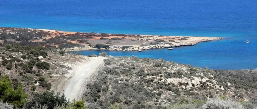
Akamas: how to choose a route and prepare for your trip
About the place
Checked: 13 September 2026.
Akamas is a region, not just a single lagoon
The Akamas Peninsula covers around 17,000 hectares in the west of Cyprus; approximately 7,000 hectares are state-owned forests. It is a large nature reserve within the Natura 2000 network, not just a single viewpoint. Visitors should choose a specific entry point, an official trail or an organised boat trip, rather than simply heading there under the general name.
Paphos, Polis, Lachi, Neo Chorio and the villages near the peninsula’s border offer different logistical starting points. The route from the south is not the same as the route from the north. Attempting to combine the gorge, Aphrodite’s Baths, several trails and the Blue Lagoon in a single day results in long journeys and superficial stops. Focusing on a single destination makes for a safer and more fulfilling day.
This new guide covers general enquiries about Akamas and does not replace the pages on individual trails. The official description of each trail remains the primary source of information on length, difficulty and starting points. The boat tour serves a different purpose and does not confirm the possibility of independent access by land to the same viewpoint.
How to choose an official trail
The Adonis and Pissouromoutti routes start at different points and have their own specifications. The term ‘circular’ means returning to the starting point, but does not guarantee an easy route. Before setting off, open the latest official map, and compare the distance, elevation gain and estimated time with the abilities of the slowest member of your group.
Save the map offline and note down the starting coordinates. Once on the trail, follow the markings; do not cross closed signs and do not cut corners through the vegetation. A random vehicle track is not a hiking trail. If the signposts have disappeared, return via a known route whilst there is still sufficient light and water.
Closed-toe footwear, a hat, sun protection and a personal supply of water are essential. The amount of water required depends on the season, the duration of the walk and the individual; a standard small bottle is not suitable for a remote summer hike. Carry food, medicines and means of communication with you; do not rely on a kiosk by the trail.
Roads, car hire and insurance
A tarmac access road to a village does not mean that the rest of the route is suitable for a standard car. On the peninsula, you will encounter dirt tracks, stones, steep sections and damage caused by the weather. Car hire terms often restrict use of such roads and off-road assistance. Before setting off, check your contract, insurance cover and the permitted route.
Four-wheel drive does not replace experience, nor does it make a slope safe. Do not attempt to follow in the footsteps of a local driver or a tour vehicle. Turning round, oncoming traffic and a lack of mobile signal can pose problems. If in doubt, leave your car at the official starting point, choose a different route or use a licensed, organised tour.
In Cyprus, they drive on the left. Check your fuel and battery levels before heading into remote areas, and plan your return journey to finish before dark. Do not park on vegetation, at a barrier or where the road is blocked by emergency services. A closed road is not an invitation to look for a detour via a neighbouring track.
Heat, communication and what to do in case of a problem
There are many open stretches in Akamas with little permanent shade. In summer, set off early and avoid the midday route. Headaches, weakness, confusion and nausea require you to stop, cool down and turn back; do not carry on to your destination just for the sake of a photograph. Do not leave anyone alone if their condition is deteriorating.
Mobile signal can be patchy in remote terrain. Before setting off, tell a friend the name of the trail, your starting point and your expected return time. Ensure your phone is fully charged, that you have an offline map, and that the group does not split up without a clear plan. In an emergency, call 112 and provide your coordinates, the official route and the nearest signpost.
Fires are strictly prohibited in nature reserves unless expressly permitted. Do not light a fire, do not throw away cigarette ends, and do not park a hot car on dry vegetation. In the event of smoke, a fire warning or instructions from the emergency services, immediately abandon your plans and follow the authorised evacuation route.
The sea, boats and the Blue Lagoon
The Blue Lagoon is often visited by boat from Laçi, but the colour of the water and whether the boat stops there depend on the weather, the vessel and the current itinerary. Compare journey times, passenger capacity, shade, safety equipment and cancellation terms. Promotional photographs do not guarantee an empty cove or the possibility of swimming on a specific day.
Follow the captain’s instructions, use the life-saving equipment provided and do not swim away from the boat on your own. Calm waters can change rapidly. Do not mix alcohol with swimming or operating the boat. It is safer for anyone without confident swimming skills to remain in the designated area near the crew.
Travelling independently along a dirt track to a remote shore is not a safe alternative to a boat trip. Check that access is permitted, assess the condition of the track and the terms of hire. Do not climb down an unofficial cliff face or enter a cave whilst the sea is rough. On an undeveloped shoreline, there is no guarantee of lifeguards, water or mobile coverage.
Seasons, nature and accessibility
Spring brings flowering and milder temperatures, but rain alters the ground and the condition of the gorges. In summer, the main factors are heat and the risk of fire. In autumn, the weather window can be pleasant, although the sea and wind conditions vary. In winter, short days and precipitation require a particularly cautious choice of route.
As this is a protected area, you must stick to authorised routes. Do not pick plants, do not disturb wildlife and take your rubbish away with you. Restrictions may apply during the breeding season or following damage to the trails. Physical signposts and up-to-date information from the authorities are more important than an old, well-preserved map.
Most nature trails are not barrier-free. A nearby car park does not guarantee a level surface, an accessible toilet or a safe turning area. For people with reduced mobility, a confirmed vantage point or a maritime programme with a verified embarkation point will be selected, but accessibility cannot be guaranteed without a specific operator’s confirmation.
Pre-planned itineraries and final checks
For the first day of walking, choose one official circular trail, set off in the morning and, upon your return, stop in the nearest village. For a day at sea, keep the boat trip as the main activity and do not add a challenging trek. A short route with an early turning point and a supply of water is ideal for families.
The day before, check the weather forecast, fire and road restrictions, the trail map and the rental agreement. On the day of your trip, assess the actual temperature, the condition of the participants and the signage on site. If conditions are unsuitable, choose an alternative route near Paphos or Polis, without trying to justify the long journey by taking risks.
Akamas is valued precisely as a natural area where plans must adapt to the terrain and conditions. A successful visit is one where the chosen itinerary is completed safely, rather than one that covers the maximum number of points. Timetables, access and ground conditions must be confirmed immediately before the trip.
Continue planning
- Paphos: a practical base for western Cyprus
- Troodos: an alternative mountain route
- Cape Greco: a nature day in the east