Trimiklini, Cyprus: the double bridge, the waterfall and the village
About the place
Checked: 29 October 2026.
Trimiklini at a glance: a village on the Kouris on the Limassol–Troodos road
Trimiklini (Τριμίκλινη) is a village in the Limassol district, in the foothills of Troodos. According to the community council, it lies about 27 km north-west of Limassol, on the main Limassol–Platres–Troodos road. The village’s average altitude is about 570 m above sea level. According to the 2021 census, it has 353 residents.
The official Greek spelling is Τριμίκλινη. In searches the name is often spelled differently, for example Τριμήκληνη, and that spelling comes with its own explanation of the name, described below. The community council notes that the village has long been a resting place for vehicles and travellers on their way to the mountains.
Trimiklini is known for its double bridge over the Kouris river, an old Venetian-era bridge, its fruit orchards and the roadside market. The Trimiklini waterfall, which people often ask about, has its own section below. For an overview of the mountain area, see our guide to the Troodos villages, trails and routes.
The history of the village and the origin of its name
According to the community council, the village already existed in the Middle Ages and appears on old Venetian-period maps as Trimichini. Three traditions explain the name. The first derives it from the words for ‘warm bed’: the village supposedly had an even climate in winter and summer, and the sick were sent here.
The second tradition links the name to the words for ‘warm spring’. The council writes that the village has a spring known as Zinon’s spring, whose water is cold in summer and warm in winter. In this version the name is spelled Τριμήκληνη. The third version derives it from the terebinth, a wild pistachio (τριμιθιά): the village may originally have been called Trimitini, which fits the old spelling on maps.
Trimiklini lay on the first road that British troops built in the Limassol district: it ran Limassol – Ypsonas – Alassa – Lania – Silikou – Trimiklini – Kouka – Pera Pedi – Platres – Troodos, to the summer residence of the first Governor of Cyprus. According to the council, part of the road still has its stone paving. The village built its old primary school at its own expense in 1926; the building has been restored and stands in the community park next to the amphitheatre.
The Kouris valley, orchards and the reservoir
According to the community council, Trimiklini sits in one of the largest basins in Cyprus, surrounded by mountain peaks, the highest of which is Zalakas (Ζάλακας). Only to the south does the village open onto a large gorge through which the Kouris river (Κούρης) flows. The village is built so that it cannot be seen whole from any single point.
Wine and table grapes, almonds, olives and fruit trees are grown around the village. The biggest harvests are of peaches, nectarines, pears and plums. The council also mentions wine and zivania that villagers make in the traditional way.
About one and a half kilometres north of the village, on the Kouris, stands the small Trimiklini dam. According to the council, it holds 340,000 cubic metres; its water irrigates the village orchards, and in summer the reservoir is a habitat for birds. Do not confuse it with the Kouris Dam further downstream, which the road from Limassol passes.
The double bridge and the Venetian bridge on the Kouris
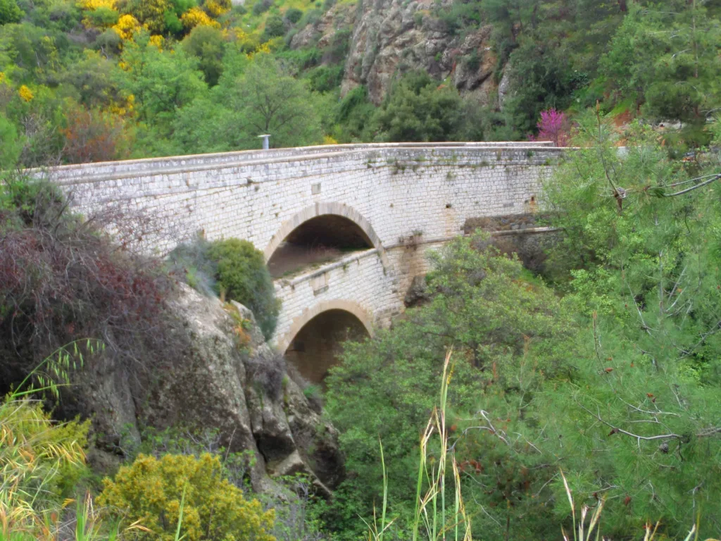
The village’s main sight is the double bridge (διπλογέφυρο). The community council calls it the only bridge of its kind in Cyprus. The first, lower level was built in 1901 for carts. The second level was added in 1917, when the first cars appeared on the island. The Limassol–Trimiklini–Troodos road ran across it.
An older bridge also survives in the Kouris riverbed, which the community council dates to the Venetian era. It is built of river stone and has three arches in a row. According to the council, this crossing linked the Paphos district with Kalo Chorio, Lefkara and Nicosia.
A church tradition is linked to the bridge: Saint Helena, travelling from Stavrovouni, is said to have crossed the river here, carrying the Holy Cross and the holy rope to the ancient Monastery of the Holy Cross in the neighbouring village of Kouka and to Omodos. The bridges stand in the river valley; before going down to them, ask locals about the way.
Trimiklini waterfall: what we know
In travellers’ reviews, ‘Trimiklini waterfall’ usually means a small waterfall by the road at the entrance to the village. We could not find a description of it in official material from Visit Cyprus, the portal of the Deputy Ministry of Tourism, or from the Department of Forests, so we do not give its exact location, height or visiting conditions.
An earlier version of this page mentioned paid entry and gave prices. We could not confirm them from official sources, so we do not repeat them: if access to the waterfall is arranged by the landowners, check the terms on site. The flow at Cyprus’s small waterfalls depends on rainfall and usually weakens by the end of summer.
If you want to see Troodos waterfalls on maintained nature trails, see our guide to hiking routes and nature trails in Cyprus.
Getting to Trimiklini and what to see on the way
A car is the most convenient option. Visit Cyprus describes the route as follows: from Limassol take the A1 motorway, then exit onto the B8 towards Troodos, past the Kouris Dam, and on to Trimiklini. Check the route on your navigation app before you set off.
According to the community council, a small market traditionally runs every day by the Limassol–Platres road, near the village coffee shops, selling zivania, wine, soutzoukos, sweets and fruit from local orchards. The council described it as the only market of its kind in Cyprus. What you can take home from the island is covered in our guide to what to bring back from Cyprus.
Trimiklini is the starting point of the Visit Cyprus ‘Pitsilia’ wine route, which leads to Pelendri, Kyperounta and Agros, and one of the stops on the ‘Commandaria’ route. Buses to mountain villages are infrequent, so without a car check the timetable with the Limassol district bus operator in advance, including the return bus.
What to check before visiting Trimiklini
What the roadside market sells depends on the season and the harvest, and stall hours vary, so do not count on shopping late in the evening. Buy fruit and homemade drinks from sellers who tell you where their produce comes from.
If you go down to the bridges and the river, wear closed shoes: the stones in the riverbed are slippery, and the water rises quickly after heavy rain. Do not enter the riverbed when it is in flood, and keep out of fenced private plots along the river.
The B8 is a busy mountain road. Park only in proper parking areas, not on the verge. In winter there can be snow and ice above Trimiklini, towards Troodos: check the road conditions report before driving into the mountains.
Continue planning
- Troodos: villages, trails and routes through the mountains of Cyprus
- Hiking routes and nature trails in Cyprus
- What to bring back from Cyprus: food, handicrafts and limits
Official sources
- 2021 Population Census — Cyprus Statistical Service (CYSTAT)
- A tour of the village — Trimiklini Community Council website (2013 archived copy)
- Cyprus Wine Routes brochure (2015) — Visit Cyprus (PDF)
The double bridge over the Kouris river at Trimiklini · Photo: Xaris333 · CC BY-SA 4.0 · converted to WebP and resized.
